Urban Water Balance Assessment for Municipalities
Short Description
The assessment of the urban water balance provides a sound basis for strategic decision-making in urban planning, settlement development, and the implementation of local stormwater management based on the sponge city principle.
The DWA Technical Guideline A 100 defines the minimization of disturbances to the natural water balance as an overarching objective in urban development projects.
Using the hydrological model ABIMO, the urban water balance can be calculated based on data on urban development patterns, soil and vegetation characteristics, and local climatic conditions. The model determines the annual distribution of precipitation among surface runoff, groundwater recharge, and evapotranspiration.
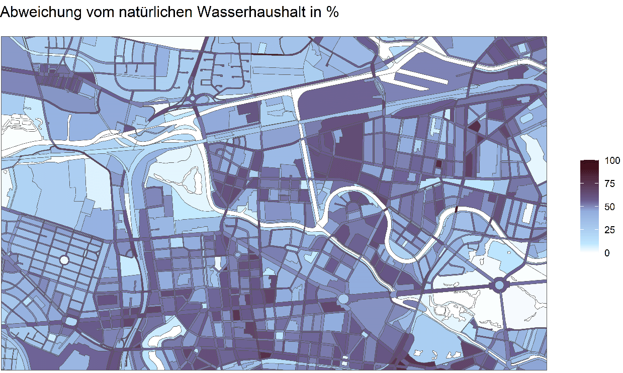
For each area, the deviation from a hypothetical natural reference state (ΔW) can be calculated. This makes it possible to identify areas where sponge city measures can be particularly effective in improving the urban microclimate or reducing the impacts of heavy rainfall events.
By adjusting the model parameters, future scenarios or hypothetical developments can also be investigated, such as changes in evapotranspiration under different climatic conditions or the effects of implementing blue-green infrastructure strategies.
With our expertise, we support municipalities, planning consultancies, and research institutions in analyzing and strategically managing the urban water balance. Our range of services is modular and can be flexibly tailored to your specific requirements.
Feasibility Check and Initial Consultation:
We assess together whether the required data are already available or can be supplemented through Open Data sources, existing geospatial data infrastructures, or other approaches.Data Analysis and Preparation:
Analysis and enhancement of existing municipal (georeferenced) datasets, supplemented by satellite data or other sources where required.Urban Water Balance Modelling:
Calculation of the current urban water balance using the ABIMO model and creation of informative maps.Near-Natural Reference Scenario:
In consultation with the client, we develop a realistic “near-natural” scenario to serve as a reference for comparison.DeltaW Analysis:
Calculation and visualization of the deviation from the near-natural state (ΔW) as a basis for targeted measures and planning.Workshops and Stakeholder Engagement:
Joint development and discussion of potential disconnection scenarios with local stakeholders.Scenario Assessment:
Calculation of the effects of planned measures, including changes in the water balance, improvements in ΔW, and assessment of climate adaptation effects.Visualization and Communication:
Provision of water balance maps as graphics and GIS data.
Specialized Expertise:
With its “Stormwater and Water Bodies” department, KWB has extensive experience in urban stormwater management and in the scientific investigation of sponge city approaches.
Independent and Impartial Consulting:
As a non-profit and independent organization, we provide objective consulting based solely on professional expertise.
In-House Development and Extension of the ABIMO Model:
The ABIMO hydrological model has been completely reprogrammed and further developed by KWB. This gives us detailed knowledge of all its technical and conceptual aspects, enabling precise and flexible application.
Transparent and Adaptable Solution:
The model code is publicly available on GitHub, making our solution fully transparent and traceable. At the same time, the input parameters can be flexibly adapted to site-specific requirements.
Accessible Scientific Communication:
We have many years of experience in communicating and translating scientific content for different audiences. This enables us to provide all stakeholders with a sound decision-making basis that is both scientifically robust and clear and easy to understand.